
At 6:04 p.m. on June 24, 2026, the ground beneath north-central Venezuela broke twice in thirty-nine seconds — a magnitude-7.2 foreshock, then a magnitude-7.5 mainshock — along the strike-slip boundary where the Caribbean Plate grinds past South America. The epicenters sat inland, near Yumare and Morón in Yaracuy and Carabobo states. Yet the dying happened somewhere else entirely: along the densely built coastal strip of La Guaira, more than 180 kilometers to the east, where pancaked apartment blocks in Caraballeda, Los Corales, Catia La Mar, and Macuto account for the overwhelming share of a toll that stood at 1,450 dead and 3,150 injured in the United Nations' June 28 situation report and has since climbed past 1,700. This is the story of why — told through the rescue that followed, the shaking science that explains the geography of the loss, and the exposure intelligence DisasterAWARE delivered to responders within hours of the first wave. Where a figure comes from a model rather than a confirmed count, we say so.
The map below plots both epicenters along the Yumare–Morón axis, the coastal La Guaira communities where building collapse concentrated, the affected hospital network, and the international Urban Search-and-Rescue sectors. The inland epicenters and the coastal damage zone are deliberately shown together — the distance between them is the central fact of this disaster. Click any point for detail.
Open map full screen in a new tab ↗
Map data: USGS NEIC, GDACS, MapAction, UN OCHA, INSARAG, and the DisasterAWARE exposure model. Forecast and warning layers are labeled separately from confirmed-impact layers.
Northern Venezuela sits on one of the most active continental transform boundaries in the Western Hemisphere. Here the Caribbean Plate slides eastward past the South American Plate at roughly 20 millimeters a year, and most of that motion is taken up by the El Pilar–Oca-Ancón fault system that runs east–west along the country's northern coast. On June 24, the rupture initiated near the junction of that system with the northeast-trending Boconó fault beneath Yaracuy and Carabobo.
The sequence was a doublet — two large earthquakes in immediate succession rather than a single mainshock and a long-delayed aftershock. The U.S. Geological Survey timed a magnitude-7.2 event at 22:04:33 UTC, followed just thirty-nine seconds later by a magnitude-7.5 event at 22:05:11 UTC (18:04 local time). Both were shallow — the mainshock at 10 kilometers — and both ruptured in a strike-slip mechanism, the side-by-side sliding of two crustal blocks. The mainshock relocated to within about 16 kilometers of Morón and 28 kilometers southeast of Yumare, at 10.435°N, 68.472°W.
Two things made that doublet unusually destructive. First, shallow ruptures deliver their energy to the surface with little attenuation — a 10-kilometer hypocenter leaves a building far less rock to absorb the wave than a deep subduction event would. Second, the thirty-nine-second spacing meant that structures already cracked and weakened by the M7.2 were struck again, at higher amplitude, before anyone could move. Buildings do not fail only at peak acceleration; they fail from accumulated damage, and this sequence delivered two doses.
The shaking radiated far. The Venezuelan Red Cross reported the earthquakes were felt across the Distrito Capital, La Guaira, Aragua, Carabobo, Miranda, and Falcón, and as far away as Colombia, the Caribbean, and the Brazilian Amazon — more than 1,700 kilometers from the epicenter, as far as Martinique. A tsunami alert was issued in the minutes after the mainshock and then cancelled; no destructive wave materialized, and the threat was formally stood down by the responsible warning centers.
By June 28, authorities had logged more than 500 aftershocks — the Venezuelan Red Cross counted over 302 in its reporting window, OCHA cited 512 — including a magnitude-4.8 on June 27. The USGS placed the probability of a magnitude-5.0-or-greater aftershock within the following week at 52 percent, and the probability of a magnitude-6.0-or-greater at roughly 43 percent. Those numbers are not academic: they governed every decision about whether to send rescuers back into leaning, half-collapsed structures.
The USGS issued a "red" PAGER alert for both earthquakes — the highest level in its Prompt Assessment of Global Earthquakes for Response system, signaling that high casualties and extensive economic losses were probable. The ShakeMap for the mainshock estimated maximum ground shaking near Modified Mercalli Intensity IX ("violent") — the level at which even well-built structures sustain serious damage and poorly built ones are destroyed.
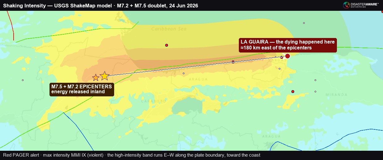
DisasterAWARE's Shaking Intensity layer (USGS ShakeMap model) for the doublet. The high-intensity band — orange to red, MMI VIII–IX — runs east–west along the plate boundary toward the coast, while the M7.2 and M7.5 epicenters sit inland. The dying concentrated some 180 km east, in La Guaira.
The USGS population-exposure breakdown for the mainshock shows the scale of the human footprint inside each shaking band:
DisasterAWARE's own exposure model, generated automatically from the hazard footprint within hours of the event, placed 13.5 million people, 2.81 million households, and $551 billion of replacement-value infrastructure inside the affected area — including 1,007 schools and 277 hospitals. The model's three-tier shaking bands tracked 12.6 million people in the outer band, 732,000 in the middle band, and 226,000 in the most intense band. GDACS, the Global Disaster Alert and Coordination System, estimated 9.73 million people affected with 530,000 exposed to severe-to-extreme intensity.
Three independent models, three different totals — and that is exactly as it should be. Each uses a different population grid, a different shaking-attenuation relationship, and a different definition of "affected." What matters operationally is that all three agreed on the same conclusion within hours: this was a catastrophe on the order of millions exposed, and responders needed to mobilize at scale immediately. The USGS PAGER model went further, flagging a fatality estimate whose probability distribution extended into five figures. That estimate is a probabilistic alert, not a body count — but it was right about the category of event, and it was available before the first rescue plane left the ground.
Here is the fact that defines this earthquake. The epicenters were inland, in Yaracuy and Carabobo. OCHA reported that those epicentral states suffered only "some material damage" — cracked roads, scattered structural impacts, an influx of patients to referral hospitals. And yet "La Guaira continues to record the highest level of impact," in OCHA's words — a coastal state more than 180 kilometers east of where the fault broke. The Government declared La Guaira, not the epicentral zone, a disaster area. The Venezuelan Red Cross's rapid damage assessment found 95 percent of infrastructure in La Guaira affected.
Why would the dying concentrate so far from the rupture? The answer is site amplification, and Venezuela has learned it the hard way before.
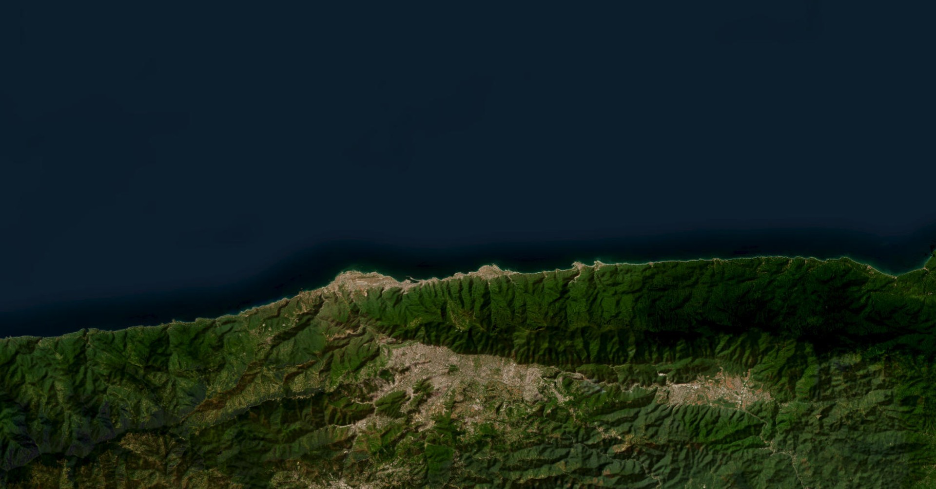
La Guaira's narrow coastal shelf — the towns of Caraballeda, Los Corales, Tanaguarena, Naiguatá, Macuto, Catia La Mar, and Mamo — is built largely on soft alluvial sediments: loose, water-saturated material washed down from the Ávila massif. When seismic waves pass from hard bedrock into soft sediment, they slow down and grow taller — the same physics that makes a wave steepen as it reaches a shallow beach. Soft basins can amplify ground motion several-fold and, critically, they ring at particular frequencies. When a basin's resonant frequency matches the natural sway of the buildings sitting on it — typically mid-rise to high-rise concrete apartment blocks — the structure and the soil oscillate in step, and the building is driven to failure.
This is not a hypothesis invented for 2026. It is the documented mechanism of the 1967 Caracas earthquake, a magnitude-6.4 event whose epicenter sat about 35 miles offshore. Despite its modest magnitude and distance, soft-soil amplification in the Caracas valley collapsed four 10-to-12-story apartment buildings and killed more than 200 people — and on this very coastline, the upper floors of the 12-story Charaima building in Caraballeda pancaked, while the 14-story Macuto Sheraton sustained severe column and shear-wall damage. Engineering studies in the decades since established the link between the soil conditions, the building heights, and the pattern of destruction. In the days before the 2026 doublet's damage was even fully assessed, engineers were again warning that tall buildings on La Guaira's soft soils were acutely vulnerable.
The collapse signatures recorded by rescue teams in 2026 are consistent with that mechanism. The INSARAG worksite dashboard documents the failure modes building by building across the La Guaira sectors: "pancake collapse," "overturn collapse," "inclined layers" — the classic failure modes of non-ductile reinforced-concrete frames, the structural type that dominates mid-century and informal mid-rise construction in coastal Venezuela. Post-event engineering assessments catalogued the vulnerability factors that turn strong shaking into mass casualties: soft or weak ground-floor stories (often open parking or shopfronts), poorly confined columns, brittle masonry infill, irregular floor plans, heavy unreinforced walls, and "pounding" between adjacent buildings constructed too close together. None of these is unique to Venezuela. All of them were present at scale on the strip of coast that took the worst of the shaking.
The same coastline carries a second, separate scar. In December 1999, the Vargas tragedy — torrential rains that triggered catastrophic debris flows down the Ávila slopes — buried parts of Caraballeda, Los Corales, and Carmen de Uria and killed an estimated tens of thousands. That was a hydrometeorological disaster, not a seismic one, and the mechanisms are unrelated. But it underscores the through-line: this is a steep, fragile, intensely developed coastal shelf where a large and vulnerable population lives stacked against the sea, and where the margin between a natural hazard and a humanitarian catastrophe is thin.
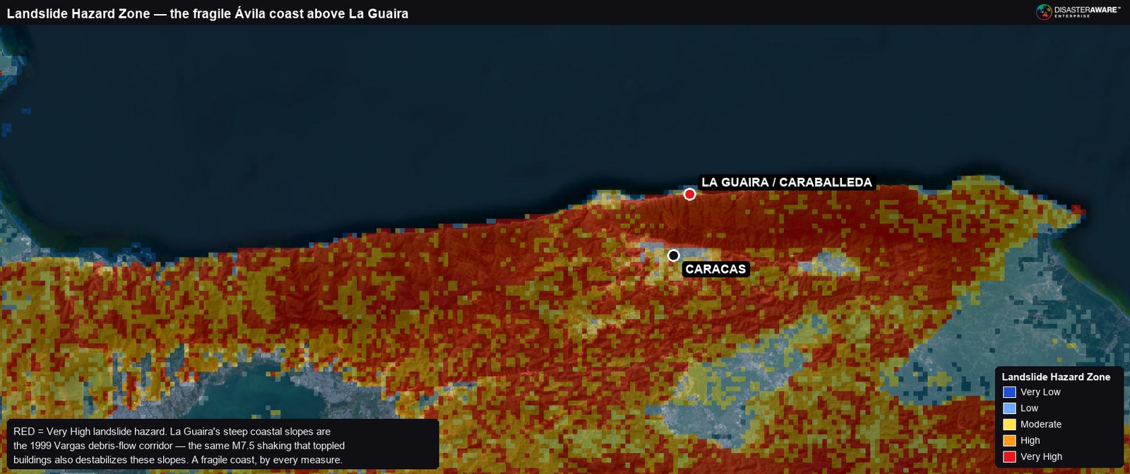
DisasterAWARE's Landslide Hazard Zone layer over the La Guaira coast. The steep Ávila slopes fronting the towns rate Very High (red) — the 1999 Vargas debris-flow corridor. The same shaking that toppled buildings also destabilizes these slopes: a fragile coast by every measure.
Layered on top of the shaking was a slower killer: the collapse of the health system itself. The Venezuelan Red Cross reported that the public health centers on which more than 90 percent of the population depends were overwhelmed by a surge of trauma cases on top of pre-existing shortages of staff, supplies, and operating theaters. Thirty-eight hospitals were damaged, including the J.M. de los Ríos Children's Hospital and Coche Hospital in Caracas; the Caracas hospital network — Pérez Carreño, Domingo Luciani, Vargas, and a structurally damaged Clínico Universitario — was saturated, with only one facility, Pérez de León I, reporting spare capacity at one point. A Project HOPE assessment of facilities found 57 percent suffering power outages, 71 percent without functioning ambulances, and 29 percent with failed cold chains; PDC reported only six ambulances functioning across all assessed facilities. When the prehospital chain breaks — no ambulances, no power, no trauma supplies — survivable injuries become fatal ones. A share of this toll was written not by the shaking but by the hours that followed it.
The international Urban Search-and-Rescue response was among the largest the hemisphere has mounted. The first foreign team — El Salvador's humanitarian mission — was on the ground by 5:00 p.m. on June 25, less than a day after the doublet. By June 28, the UN OCHA / INSARAG snapshot counted 49 USAR teams from 28 countries, with 2,358 personnel and 189 search dogs operating in-country, coordinated through an on-site UN Disaster Assessment and Coordination cell and an INSARAG On-Site Operations Coordination Centre. Teams arrived from Chile, Colombia, Ecuador, Spain, Switzerland, Germany, France, Italy, the Netherlands, the United States, Jordan, Qatar, Türkiye, Mexico, Brazil, Argentina, Peru, Panama, Portugal, and beyond.
The operation concentrated almost entirely on the La Guaira / Vargas coast, organized into lettered sectors — Macuto, Caraballeda, Catia La Mar, and a newly opened Sector G in Caraballeda. The worksite roll-up tells the story of the race in raw numbers: 182 collapse worksites registered, 68 survivors confirmed alive at active sites, 515 deceased recovered, and 788 people still listed as missing across the worksites as of June 28. Among the sites: D154, where rescuers reported hearing voices from within a debris pile and Dutch and German teams were tunneling in; and D159, a building where as many as 50 children had reportedly gathered for a birthday party, last heard from at 11:00 a.m. on June 27.
But the most revealing figure in the entire response is a coordination failure: of 48 teams in theater, only 22 had been tasked to a worksite. One hundred twenty-two of 182 registered worksites remained uncovered. More than a thousand rescue personnel and 117 search dogs stood available but unassigned — not for lack of will, but for lack of a unified, real-time picture of which collapse sites held survivors and which teams were free to reach them. The Venezuelan Red Cross named the same problem bluntly: despite the presence of many actors, there was a critical gap in a single unified field command. In the first hours of an earthquake, when the survival window for trapped victims is measured in days and closing, the binding constraint is rarely the number of rescuers. It is the quality of the information that routes them.
That window was closing under its own pressure. Every one of those 500-plus aftershocks forced teams to pause, evacuate leaning structures, and reassess — the 52-percent chance of a major aftershock was not a statistic on a page but a recurring order to stop digging. Rescue was already transitioning toward recovery; embassies had begun procuring refrigerated morgue containers, and the Social Security morgue in La Guaira was reporting capacity constraints against the projected caseload.
And still there were the rescues that justify the whole apparatus. News crews captured a mother pulled alive from the rubble hours after the quakes, who said her two-week-old son had given her the motivation to survive. Every one of the 68 confirmed-alive worksite reports is a moment like that — and the argument for getting the coordination right is that there were 122 untasked sites where more of them might have been waiting.
Beyond the collapse sites, the doublet produced a sprawling secondary emergency. OCHA reported more than 12,700 people formally displaced, with tens of thousands more spending their fourth consecutive night outdoors — sheltering in parks, plazas, and informal camps, many afraid to re-enter cracked but standing buildings. The PDC brief estimated more than 70,000 households affected; the Venezuelan Red Cross reported over 73,000 families assisted in some form.
Water was the next crisis. The Red Cross reported the total collapse of the potable-water network in Boca de Aroa, Falcón, forcing the population onto tanker trucks, and water infrastructure failures across all affected states. Humanitarian agencies flagged a rising risk of acute watery diarrhea and cholera as displaced populations crowded into shelters without sanitation — a textbook second wave of post-earthquake mortality if not contained. In one Caracas shelter, the Red Cross documented 400 families and 600 children with a single working tap and collapsed toilets; in another, 1,069 people sheltering under park-service management still lacked showers and bedding.
The numbers that have to be handled most carefully are the missing. Worksite-level rescue accounting put 788 people missing at registered collapse sites — a rigorous, location-anchored figure. Separately, the Government and local media cited more than 50,000 people "reported missing" through hotlines and family-tracing platforms. Those two numbers measure different things. The larger figure reflects, in large part, the collapse of telecommunications across La Guaira: when cell coverage and power fail simultaneously, families cannot reach relatives, and "unreachable" is reported as "missing." Both numbers are real; only the smaller one represents confirmed entrapment. A responsible reading holds both in view without conflating them.
In the first hours after a catastrophic earthquake, the scarce resource is not compassion or even capacity — it is a coherent, shared operating picture. The Venezuela response had 49 world-class rescue teams and left two-thirds of its collapse worksites uncovered, because the information that should have routed them was fragmented across agencies, languages, and channels.
This is the problem DisasterAWARE Enterprise is built to solve. Within hours of the June 24 doublet, the platform had ingested the USGS NEIC parameters, generated an automated exposure assessment — 13.5 million people, 2.81 million households, $551 billion of infrastructure, 1,007 schools, 277 hospitals, with modeled water, shelter, and food needs — and attached the authoritative downstream reporting as it arrived: OCHA situation reports, Venezuelan Red Cross sitreps, INSARAG USAR snapshots, MapAction building-damage assessments, REACH and UNDP field analyses. Every USGS reading, every tsunami advisory and stand-down, every agency damage map, and every exposure layer lands on a single map, attributed to the same population and asset model, with lifecycle tracking that keeps a doublet and its 500 aftershocks linked as one continuing event rather than hundreds of disconnected alerts.
The PAGER red alert and the automated exposure estimate were available before the first rescue flight departed. The value of that intelligence is not that it replaces the responders on the ground — it is that it gives every responder, in every country, the same answer to the only questions that matter in the first 72 hours: Where is the shaking worst? Who is exposed? Which structures fell? Where are the survivors, and who is free to reach them? That is the difference between 22 teams tasked and 49.
The acute phase is giving way to recovery, but the hazard has not switched off. The aftershock sequence will continue for weeks, and the standing, weakened building stock across La Guaira and Greater Caracas remains a live danger — a Presidential commission has been established to assess the habitability of damaged housing before residents return. The secondary risks now lead: water and sanitation, communicable disease in crowded shelters, the mental-health toll on a displaced population, and the structural-engineering task of triaging which buildings can be reoccupied and which must come down.
The longer reckoning is about preparedness. The 1967 Caracas earthquake taught Venezuela precisely how its coastal soils amplify shaking and precisely which buildings fail. The lesson available from June 24, 2026 is the same one, written larger: in seismic country, the epicenter tells you where the energy was released, but the soils and the structures tell you where people will die. Closing that gap — between what we already know about site amplification and vulnerable construction, and where people actually live and build — is the work that outlasts any single response.
This analysis draws on the U.S. Geological Survey (NEIC, ShakeMap, and PAGER products), the Global Disaster Alert and Coordination System (GDACS), UN OCHA Situation Report No. 5 (June 28, 2026), the Venezuelan Red Cross Situation Report No. 6, UN OCHA / INSARAG Urban Search-and-Rescue snapshots, MapAction damage assessments, the Pacific Disaster Center, and the DisasterAWARE exposure model, covering the period June 24–29, 2026. Casualty and damage figures from an active humanitarian emergency are preliminary and were rising at the time of writing; each figure is attributed to its source and reporting date. Modeled exposure and probabilistic alert estimates are identified as such and are distinct from confirmed counts. Published by DisasterAWARE as a public-interest analysis; operational hazard intelligence is available to enterprise subscribers.


-min.png)


.png)


.png)


Decision-ready intelligence for understanding what's happening, what is impacted, and what to do next. Global hazard, severe weather, catastrophe, and physical risk intelligence trusted by governments, enterprises, insurers, humanitarian organizations, and technology platforms worldwide.
Request DemoContact Us