Volcanic eruptions, while relatively rare, can have outsized impacts on lives, economies, and global business operations. Approximately one billion people (12% of the world’s population) live within 150 km of an active volcano, creating significant risks to communities and critical infrastructure. Immediate volcanic threats such as destructive ashfall, lava flows, and pyroclastic blasts can cause catastrophic losses. For instance, the 1991 Mount Pinatubo eruption in the Philippines resulted in over $1 billion in economic damages, including widespread aviation disruptions. Similarly, the 2010 Eyjafjallajökull eruption in Iceland led to more than 100,000 flight cancellations, causing economic losses estimated between €1.5–2.5 billion across Europe. DisasterAWARE® addresses this need by providing an integrated platform for global volcano surveillance, alerting, and impact analysis.
DisasterAWARE continuously monitors volcanic activity worldwide, providing real-time situational awareness to rapidly assess emerging threats. The platform integrates data from authoritative sources—including national volcano observatories and Volcanic Ash Advisory Centers (VAACs)—with Pacific Disaster Center’s advanced analytics. Upon detection of volcanic activity, DisasterAWARE generates a Hazard Brief, delivering concise yet comprehensive insights. Each brief includes key details such as:
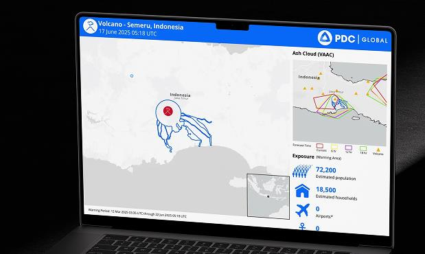
By consolidating this critical information into a clear, visual report, DisasterAWARE enables businesses, emergency managers, and insurers to quickly understand volcanic impacts and implement informed, proactive responses.
DisasterAWARE categorizes volcanic hazards into three standardized severity levels—Advisory, Watch, and Warning—aligning closely with international volcanic alert standards (e.g., Volcanic Ash Adisory Centers - VAAC):
Indicates an eruption is underway or imminent, often with significant ash cloud emissions. This level is also triggered when heightened volcanic unrest poses a high risk to nearby populations, or when an ash cloud is both observed and forecasted.
Issued when there’s a minor eruption or heightened unrest with a moderate risk to populations nearby. Signs of elevated volcanic unrest without imminent eruption can also prompt this severity classification if the risk remains moderate.
Assigned when volcanic unrest poses a very low risk to the nearby population, or when the volcano has returned to normal (non-eruptive state). This classification also applies if no ash cloud has been observed or forecasted.
DisasterAWARE integrates real-time data from authoritative sources, including volcanic activity alerts, risk assessments, and aviation impact analysis (VAAC codes), ensuring accurate and timely hazard severity determination to support operational decision-making.
Timely alerts are essential for protecting people and assets from volcanic hazards. DisasterAWARE’s SmartAlert™ system lets users customize notifications for specific regions of interest. While the platform provides global alerts by default, users can define alert zones—such as around Southeast Asia or key facilities—and receive notifications only when a volcano in that area enters Watch or Warning status. Alerts can be delivered via email, SMS, or in-app, and can be filtered by hazard type and severity level to reduce noise and focus on the most critical threats.
DisasterAWARE automatically defines exposure areas for each active volcano to assess who and what may be at risk. A default radius (e.g., 10 km) is applied initially, and refined as more detailed hazard zones—such as ashfall forecasts or evacuation areas—become available. Within seconds of an alert, the system maps the impact zone and estimates the exposed population and infrastructure. The Hazard Brief displays key metrics like number of people affected, critical facilities (e.g., airports, hospitals), and transportation routes within the hazard area. This rapid analysis helps answer “Who and what is in harm’s way?” so emergency managers and businesses can quickly determine whether to evacuate, reroute, or suspend operations.
DisasterAWARE includes powerful Asset Protection tools that help organizations monitor how hazards—such as wildfires—affect the people, places, and infrastructure they care about most.
Once loaded, assets can be viewed in two ways: through the Notification Panel, or by enabling their associated map service layer under the User folder in the Layers Panel.Assets can be user-owned or shared at the organization level. Organizations with multiple teams can also set up Sub-Organizations, each with their own asset classes and notification rules—providing flexibility in how asset data is managed and accessed across departments.
For each asset class, users can define non-user contacts—such as building managers or emergency coordinators—who should receive notifications when a hazard threatens specific locations. These contacts receive email alerts with detailed hazard information, ensuring they stay informed even if they don’t actively use the platform.
These features help organizations stay ahead of emerging threats, understand the geographic relationship between hazards and their assets, and quantify their total exposure—supporting faster, more informed decisions during critical moments.
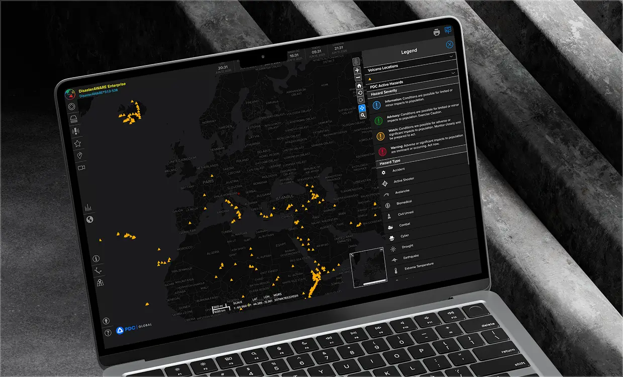
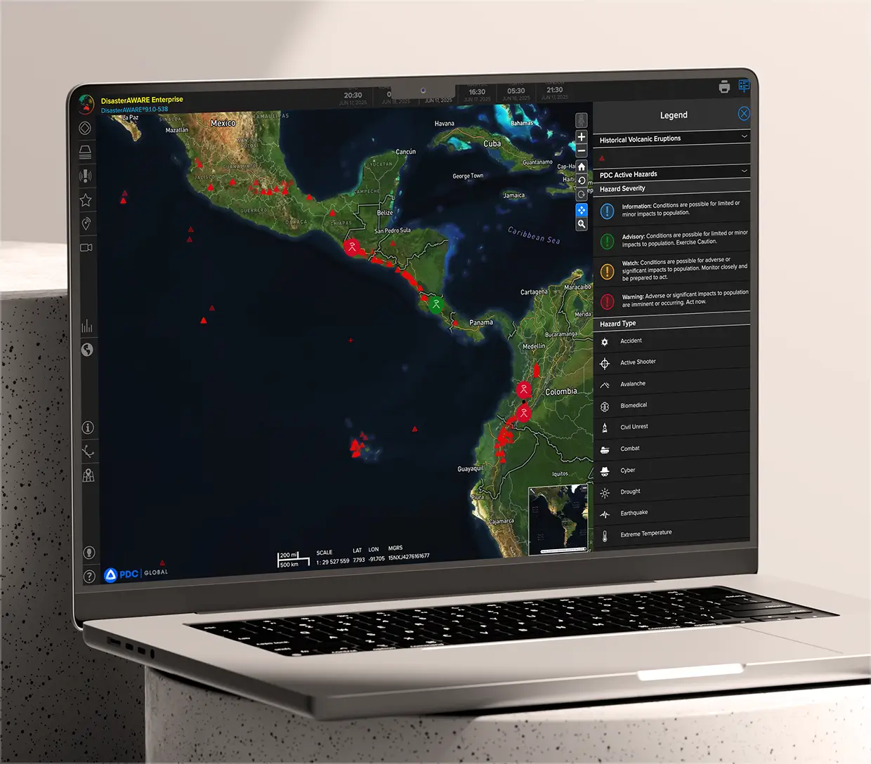
DisasterAWARE provides comprehensive supplementary layers to enhance volcanic situational awareness and risk assessment. Key layers for volcano monitoring include:


Displays both initial ash cloud extents and official aviation advisories (VAAC). DisasterAWARE also includes 6, 12, and 18-hour ash cloud forecasts, critical for aviation safety, emergency response, and operational continuity planning.
Real-time layers depicting current notification (SmartAlerts) and exposure zones for all active volcanoes. These layers provide clarity on geographic areas at risk, enabling targeted communication and precise response planning.
Sourced from the Smithsonian Institution’s Global Volcanism Program, this database includes detailed records of past eruptions, capturing eruption type, Volcanic Explosivity Index (VEI), start and end dates (where known), and supporting evidence. The VEI ranges from 0 to 8, indicating increasing explosivity, with each increment representing roughly an order-of-magnitude increase in eruption size.
This layer visualizes the density of historical volcanic eruptions based on the explosivity (VEI) and eruption duration. It extends eruption data points by 100 km to represent areas potentially impacted by volcanic emissions or ground shaking. Derived from global eruption records over the past 10,000 years (up to 2002), the data helps organizations identify regions historically vulnerable to volcanic hazards, supporting long-term risk management and preparedness efforts.
By integrating real-time volcanic activity, historical context, and exposure assessments, DisasterAWARE empowers users to better understand volcanic risks, anticipate impacts, and effectively manage preparedness and response.
DisasterAWARE’s volcano hazard intelligence is also available through our Data as a Service (DaaS) API, enabling seamless integration into client applications, dashboards, and workflows. The API feed provides comprehensive hazard information, including:
By providing real-time, operational-grade volcano data directly via API, DisasterAWARE empowers organizations to enhance preparedness, reduce response times, and strengthen resilience against volcanic threats.
Decision-ready intelligence for understanding what's happening, what is impacted, and what to do next. Global hazard, severe weather, catastrophe, and physical risk intelligence trusted by governments, enterprises, insurers, humanitarian organizations, and technology platforms worldwide.
Request DemoContact Us