


Natural catastrophes are becoming an increasingly important consideration for insurance companies. Hurricanes, floods, wildfires, tornadoes, hail, severe storms, earthquakes, and other hazards can affect thousands of properties in a matter of hours. For insurers, understanding these events requires more than knowing that a catastrophe is approaching.
Insurance teams need to know what is happening, where it is happening, how the event is evolving, what may be exposed, and what actually happened. This is where Natural Catastrophe Intelligence, or Nat Cat Intelligence, comes into play.
Nat Cat Intelligence is the collection, analysis, and delivery of timely information about natural catastrophe events to help organizations understand hazards, exposure, and impacts. It can combine information from weather and geological agencies, satellites, radar, sensors, ground observations, and other authoritative data sources to create a more complete picture of an event.
For insurers, that intelligence can help answer questions such as:
The goal isn't simply to collect more data. It is to turn disparate observations into timely, geographic, and actionable intelligence about real-world events.
Nat Cat Intelligence and catastrophe modeling are closely related, but they answer different questions.
Catastrophe modeling asks: What could happen, and what could it mean financially for an insurance portfolio? Catastrophe models use scientific, engineering, exposure, vulnerability, and financial data to simulate potential events and estimate possible losses.
Nat Cat Intelligence asks: What is happening right now, what has happened, and where did it happen? It brings together observations from sources such as weather agencies, satellites, radar, sensors, and other authoritative data to provide a detailed picture of actual catastrophe events.
Consider a hurricane.
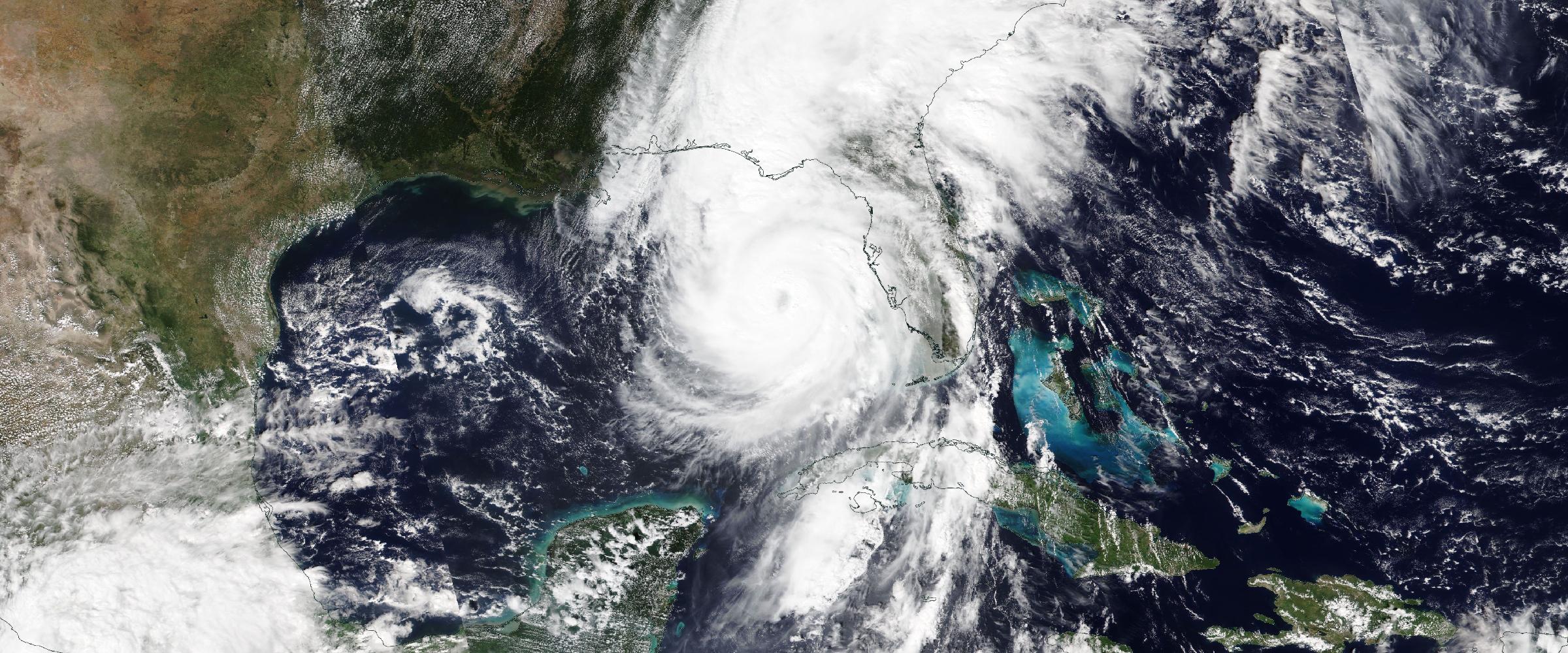
A catastrophe model might help an insurer understand the potential losses associated with thousands of hypothetical hurricanes affecting its portfolio. Nat Cat Intelligence can help the insurer understand the actual hurricane unfolding today—where the storm is, how it is evolving, which areas are being affected, and which insured locations may be exposed.
The same distinction applies across other hazards.
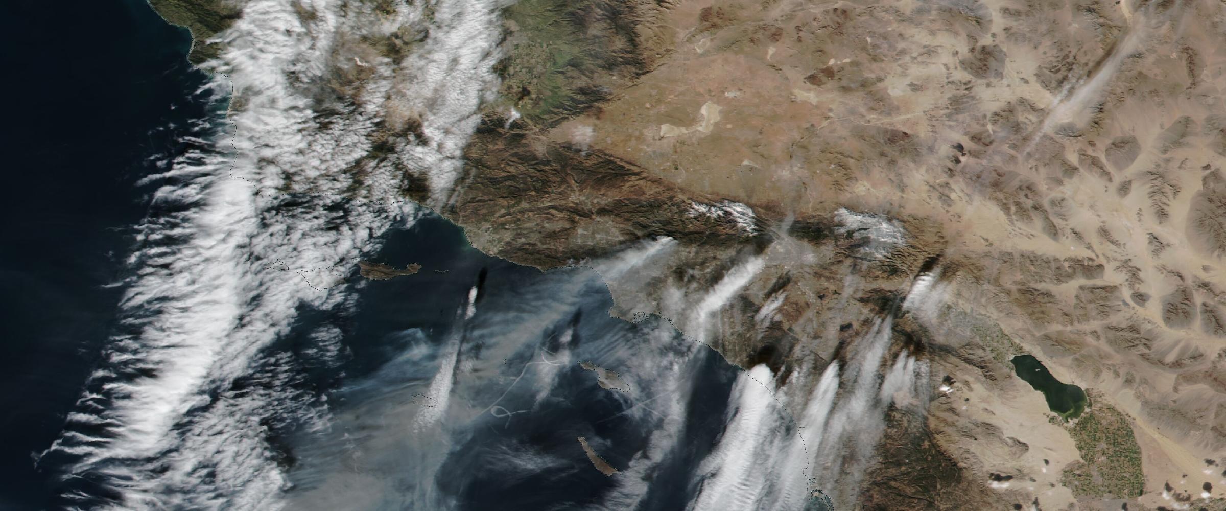
A catastrophe model can estimate potential wildfire losses across a portfolio. Nat Cat Intelligence can track an active wildfire, its evolving perimeter, and the locations potentially exposed to it.
A catastrophe model can quantify potential flood risk. Nat Cat Intelligence can provide information about an actual flood event and its observed or modeled extent as conditions change.
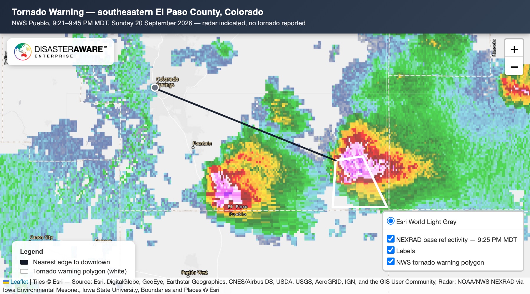
A catastrophe model can help quantify tornado risk. Nat Cat Intelligence can identify an active tornado, its track, footprint, severity information, and potentially affected locations.
Catastrophe modeling helps insurers understand what could happen. Nat Cat Intelligence helps them understand what is actually happening. These capabilities can work together to provide a more complete view of catastrophe risk.
See natural catastrophes as structured events
DisasterAWARE Historical Event Intelligence delivers catastrophe events as footprints with dates, severity and source provenance — ready to intersect with your own portfolio data.
Natural catastrophes are dynamic. A hurricane changes direction. A wildfire perimeter expands. Flooding spreads. A tornado develops and moves through a community. A severe storm produces hail across a metropolitan area. During an active event, insurance teams need information that keeps pace with those changes.
Real-time Nat Cat Intelligence can help insurers understand:
This information can support catastrophe response teams, claims organizations, portfolio managers, underwriters, and other insurance professionals.
It can also provide important context after an initial alert. A warning may indicate where a threat could occur. Subsequent observations can help establish where the event actually occurred and what its footprint looks like.
One of the most valuable characteristics of Nat Cat Intelligence is its geographic dimension. Knowing that a wildfire is burning in California is useful. Knowing the wildfire's current footprint and which insured properties are located within or near that footprint is much more actionable.
The same concept applies across natural hazards.
Hazard intelligence + geographic footprint + insured locations = exposure intelligence.
For example:
This allows insurers to move from:
“A catastrophe is occurring in this region.”
To:
“These specific locations may be exposed to this event.”
That distinction becomes increasingly important as insurance portfolios become larger and more geographically distributed.
Modern catastrophe intelligence increasingly incorporates satellite imagery, remote sensing, radar, and other geospatial technologies. These sources can provide valuable observations about rapidly changing events, including:
Synthetic-aperture radar, or SAR, can provide another source of information for observing certain events, including areas affected by flooding.
But the value isn't simply in having access to imagery. For insurers, the greater opportunity is turning these observations into structured event intelligence that can be analyzed alongside exposure data.
The result is a more useful workflow:
Observe → Map → Analyze → Identify Exposure → Assess Impact
Nat Cat Intelligence can support multiple functions across an insurance organization.
Historical and current hazard information can provide additional geographic context when evaluating a property, account, or geographic market. Underwriters can use historical event information to better understand the catastrophe environment surrounding a location and complement other underwriting data.
Portfolio teams can analyze where insured locations overlap with active and historical hazard activity. This can help identify geographic concentrations and investigate potential accumulation. For example, an insurer could analyze how many properties and how much insured value are located near historical tornado tracks or within areas repeatedly affected by wildfire.
During an active event, real-time intelligence can help catastrophe teams understand which markets may be affected and prioritize areas for further investigation. Rather than monitoring an entire region equally, teams can focus attention where the hazard and portfolio overlap.
After an event, hazard footprints and other impact information can help identify properties that may warrant additional review. Importantly, hazard exposure does not automatically mean damage. Being inside a wildfire perimeter, tornado track, or flood footprint does not by itself establish that a property experienced a covered loss. Instead, event intelligence can provide another layer of evidence that claims teams can combine with first notice of loss, imagery, adjuster assessments, and other information.
Nat Cat Intelligence can also support parametric insurance workflows. Parametric products use predefined, objective measurements—such as wind speed, rainfall, earthquake magnitude, or other event characteristics—to determine whether a policy trigger has been met. Reliable event intelligence can provide the observations required to evaluate those triggers.
Another important distinction in catastrophe intelligence is the difference between what is forecast to happen and what is actually happening. Forecasts are essential. They provide advance notice of potential hazards and help insurance organizations prepare. But once an event begins, the questions change.
A forecast might indicate: A hurricane could produce damaging winds across a particular region.
Observed intelligence can help answer: Where are damaging conditions actually occurring, and how is the affected area evolving?
Similarly:
Forecast: Heavy rainfall could produce flooding.
Observed: Flooding has occurred in these locations, and the affected footprint is expanding.
This progression—from forecast to observation to impact—can be particularly valuable during catastrophe response.
Real-time intelligence answers: “What's happening now?”
Historical intelligence answers: “What has happened before?”
A structured historical catastrophe dataset allows insurers to analyze events across years or decades and compare them with current portfolios. For example:
Historical event intelligence can complement catastrophe modeling by providing a record of observed events, rather than simulated scenarios. It can also help insurers understand how their portfolios have interacted with natural hazards over time.
There is an important difference between receiving catastrophe alerts and having catastrophe intelligence.
An alert might tell an insurer: A wildfire has been detected.
Intelligence can provide considerably more context: A wildfire has been detected, this is its current location and footprint, it has evolved over this period, these insured locations are potentially exposed, and additional information is available about the event and its impacts.
The difference is context and actionability.
For insurers managing large portfolios, that context can help connect an individual hazard signal to specific locations, exposures, and workflows.
Insurance companies rely on multiple sources of information to understand catastrophe risk.
Nat Cat Intelligence can help connect these information layers around actual catastrophe events.
The result is a more continuous information flow:
Forecast → Detection → Observation → Exposure → Impact → Historical Record
Each stage answers a different question. Together, they can provide insurers with a more complete understanding of catastrophe risk.
As satellite technology, artificial intelligence, geospatial analytics, weather observations, and data infrastructure continue to advance, catastrophe intelligence is becoming increasingly granular.
The industry is moving beyond:
“A catastrophe occurred somewhere in this region.”
toward:
“This specific event occurred here, this is how it evolved, these locations were exposed, and this is the evidence available about its impact.”
For insurers, that level of detail can support faster event response, more informed exposure analysis, more efficient claims workflows, and richer historical risk analysis.
Nat Cat Intelligence doesn't replace catastrophe modeling, claims data, underwriting expertise, or other insurance analytics.
It adds another critical layer: a continuously updated intelligence layer describing the natural catastrophes actually happening in the real world.
The value of Nat Cat Intelligence isn't simply in collecting more catastrophe data.
It's in making that data timely, geographic, contextual, and actionable. For insurance companies, that means moving beyond simply knowing that a natural catastrophe occurred—and toward understanding:
That is the role Nat Cat Intelligence can play across the modern insurance lifecycle—from underwriting and portfolio management to catastrophe response, claims, and historical risk analysis.
DisasterAWARE provides real-time and historical natural catastrophe intelligence across a broad range of hazards, combining authoritative data sources, geospatial analytics, satellite and observational data, and event-level intelligence. The platform helps organizations monitor active hazards, understand event footprints, analyze exposure, and incorporate observed catastrophe intelligence into their risk workflows.
Explore the historical record
Decades of reconstructed, verified catastrophes — browse the Historical Event Intelligence overview, or request sample data for your own portfolio.
What is Nat Cat Intelligence? Nat Cat Intelligence is the collection, analysis and delivery of timely information about natural catastrophe events, to help organizations understand hazards, exposure and impacts. It combines information from weather and geological agencies, satellites, radar, sensors, ground observations and other authoritative sources into a structured picture of each event.
How is Nat Cat Intelligence different from catastrophe modeling? Catastrophe models provide probabilistic views of potential future events. Nat Cat Intelligence describes actual events — where a catastrophe is occurring, how it is evolving, which locations may be exposed and what evidence exists about its impact. The two are complementary, not competing.
Does a property inside a hazard footprint have a covered loss? Not necessarily. Being inside a wildfire perimeter, tornado track or flood footprint does not by itself establish that a property was damaged. Event intelligence is one layer of evidence that claims teams combine with first notice of loss, imagery and adjuster assessments.




































































-min.png)


.png)


.png)









Decision-ready intelligence for understanding what's happening, what is impacted, and what to do next. Global hazard, severe weather, catastrophe, and physical risk intelligence trusted by governments, enterprises, insurers, humanitarian organizations, and technology platforms worldwide.
Request DemoContact Us

