



Why Understanding How a Disaster Unfolded Is Just as Important as Knowing That It Happened
What if you could watch history unfold again?
Imagine being able to replay Hurricane Ian from the moment it formed in the Atlantic through landfall and its eventual dissipation. Watching every advisory. Every change in intensity. Every expansion of hurricane-force winds. Every tornado spawned by the storm. Every flood that followed.
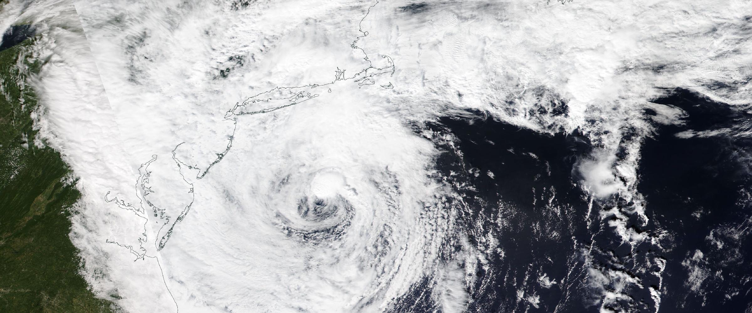
Banner: Hurricane Florence approaching the US East Coast, September 12, 2018 (NASA Worldview, VIIRS/Suomi NPP). Two days before landfall — the moment when every operational decision still had to be made.
Now imagine doing the same for a wildfire. Watching the fire ignite. Spread. Merge. Generate smoke plumes. Trigger evacuation orders. Impact air quality hundreds of miles away.
Or replaying a tornado outbreak. Seeing storms develop across multiple states. Following hail swaths, damaging winds, tornado touchdowns, and damage surveys as they unfolded over the course of a single afternoon.
This isn't simply historical visualization. It's Historical Catastrophe Intelligence. Because understanding how a disaster evolved is often far more valuable than simply knowing where it occurred.
Most historical catastrophe databases preserve a single moment in time.
Those records are valuable. But they represent snapshots. Disasters are not snapshots. They are dynamic events.
Every catastrophe evolves. Storms strengthen and weaken. Wildfires expand, merge, and change direction. Floodwaters rise, spread, and recede. Earthquake impacts become clearer as assessments continue.
Organizations that rely on static historical records often miss the most important part of the story — the evolution.
Consider a business continuity manager responding to a hurricane. The most important question isn't simply: Where did the hurricane make landfall?
The real questions are:
Those are questions about time. Not geography. Replaying historic disasters allows organizations to answer them.
Historical Catastrophe Intelligence organizes disasters as evolving operational events.
Instead of storing one record for one disaster, DisasterAWARE preserves the event as a timeline.
Every observation contributes another chapter. Every advisory. Every warning. Every survey. Every verified observation. Every update.
Together they create a living history of the catastrophe. It's a different foundation than a weather archive, and we explained why in why historical weather data isn't enough.
A hurricane is one of the clearest examples of why timelines matter. Traditional historical datasets often show a single storm track. That tells only part of the story. Historical Catastrophe Intelligence preserves the evolution of the storm itself. Organizations can replay:
Instead of asking where did the hurricane go?, organizations begin asking how did the hurricane evolve — and when did risks begin to emerge?
Severe Convective Storms are among the fastest-changing natural hazards. A storm that appears relatively harmless at noon may produce destructive hail, damaging winds, and multiple tornadoes an hour later. Historical replay captures that evolution. Organizations can visualize:
Rather than viewing isolated reports, analysts can follow the complete lifecycle of the event. That perspective is invaluable for insurers, emergency managers, and post-event investigations.
Replay decades of catastrophes, not just look them up
Hurricanes, floods, wildfires, earthquakes, and Verified Severe Convective Storms preserved as evolving timelines — delivered through APIs, GIS services, and dashboards.
Wildfires rarely remain confined to one location. They evolve continuously.
Fire behavior changes with weather, terrain, fuels, and suppression efforts.
Historical Catastrophe Intelligence allows organizations to replay:
Understanding when smoke affected operations or when evacuation zones expanded often proves just as important as understanding where the fire burned.
Flooding is one of the most dynamic natural hazards. Water rises. Flows. Expands. Changes direction. Eventually recedes.
Historical replay enables organizations to understand:
Rather than viewing one flood map, organizations can understand how the flood developed over time.
Earthquakes occur within seconds. Their impacts unfold over days. Historical replay captures:
This helps organizations understand not simply where the earthquake occurred — but how impacts developed during response and recovery.
One of the greatest values of replaying historic disasters is education. Organizations routinely conduct:
Historically, these exercises relied on reports, spreadsheets, and static maps. Historical replay transforms those exercises.
Participants can watch the disaster unfold exactly as it did. Decision-makers experience the event as it evolved — not simply as it ended. That creates a far richer understanding of operational decision-making.
Imagine preparing a crisis management team using Hurricane Ian. Rather than reading a timeline, the team experiences the storm's evolution. At each stage, participants must decide:
Historical replay transforms past catastrophes into realistic training environments. Organizations aren't studying history. They're learning from it.
Historical replay also improves post-event analysis. Organizations can examine questions like:
Instead of reviewing isolated observations, analysts understand the complete operational sequence. Tied to a specific portfolio of assets, that sequence becomes Historical Exposure Intelligence.
That context leads to better planning for future events.
Every catastrophe leaves behind lessons. Some are obvious. Others only become visible when the disaster is viewed as a complete sequence of events.
Historical Catastrophe Intelligence makes those lessons accessible. Replaying historic disasters transforms decades of hurricanes, floods, wildfires, earthquakes, and Severe Convective Storms into living case studies that organizations can revisit again.
Because resilience isn't built by remembering where disasters occurred. It's built by understanding how they unfolded — and applying those lessons before the next catastrophe arrives.
Explore the historical record
Decades of reconstructed, verified catastrophes — browse the Historical Event Intelligence overview, or request sample data for your own portfolio.
What does it mean to "replay" a historic disaster? It means the catastrophe is stored as a timeline rather than a single record. Every advisory, warning, survey, verified observation, and update becomes another chapter, so the event can be stepped through as it actually unfolded instead of being read as one final snapshot.
Which hazards can be replayed? Hurricanes (formation, advisory-by-advisory track and intensity, wind field expansion, wind radii by quadrant, landfalls, duration), Verified Severe Convective Storms (development, hail, radar-derived swaths, wind reports, tornado touchdowns, damage surveys), wildfires (ignition through perimeter expansion, smoke, air quality, evacuations), floods (onset, inundation growth, peak extents, depths, gauges), and earthquakes (shaking intensity, PGA, Modified Mercalli Intensity, ShakeMap evolution, aftershocks).
How is replay used for training and exercises? After-action reviews, tabletop exercises, emergency response training, crisis simulations, and business continuity planning. Instead of reading a timeline in a report, participants watch the event evolve and make decisions at each stage — close facilities, evacuate, contact suppliers, reroute transportation, notify customers — as the conditions change.
Why does the timeline matter more than the location? Because operational decisions are made in time, not geography. When hurricane-force winds first threatened a site, when flooding began, when roads became impassable, and how quickly conditions deteriorated are the questions that drive planning and post-event analysis — and none of them can be answered from a static map.




Decision-ready intelligence for understanding what's happening, what is impacted, and what to do next. Global hazard, severe weather, catastrophe, and physical risk intelligence trusted by governments, enterprises, insurers, humanitarian organizations, and technology platforms worldwide.
Request DemoContact Us

